The “Wheel” Line:
Ideas and Implications
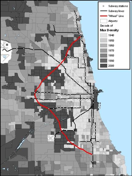
I would like to assume that areas that have recently reached their maximum density are those that are likely to continue growing. As such, these are the areas that would be best served by the addition of a transit line.
As I mentioned in my intro, a common criticism of the “L” is that it does not have very good coverage. One can not travel between suburbs without connecting through the city unless they are on the same line. Since the “L” is already in the formation of the spokes of a wheel, they are perfectly fit to be connected by a wheel, what I have here called the “Wheel” Line. The Wheel Line would connect the various lines somewhere from their midpoint to around their outermost terminus points. It would allow for inter-suburban travel.
But as this map shows, it would also allow for the connection of many up-and-coming neighborhoods. The dark patches being connected here, once again, are the tracts that reached their maximum density in 2000. These neighborhoods must be experiencing a good amount of growth or improvement to warrant this peak in population density, so these communities would likely be well served by transit lines connecting through their neck of the woods. Although the Wheel Line as depicted here is only a rough estimation of where it might run, the on-the-ground pattern is pretty clear that those in between neighborhoods are underserved by the current array of lines.
The past 60 years have marked a period of decline for the city of Chicago versus a period of growth for the metropolitan area in general. The “L” is a fantastic urban resource, but it is brutalized by criticism over its deteriorating condition and its poor service routes. The Chicago “L” might have been well suited for the population density patterns of 1940, but by the time of Census 2000 the lines were missing some of the more booming Chicago neighborhoods. Through the addition of a Wheel Line, the Chicago “L” could preserve its historic routes while also providing service to neighborhoods which could benefit from subway service now more than ever.
Acknowledgements:
Chicago “L”.org (http://www.chicago-l.org)
Color Brewer (http://www.colorbrewer.org)
Special thanks to Jonathan Schroeder of Middlebury College for his data set.